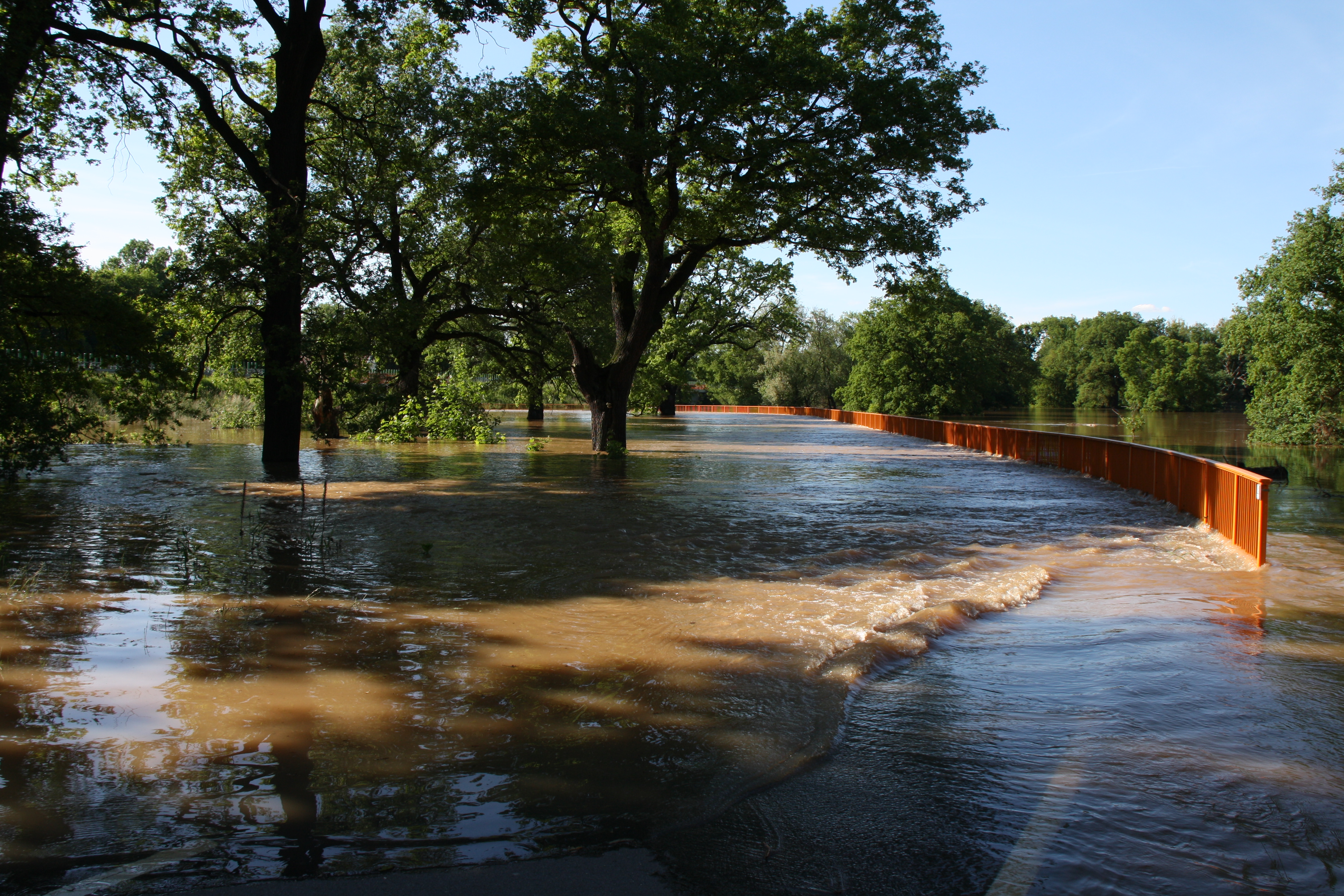
Click to enlargeFlooded elbe river near Dessau Source: Jörg Rechenberg / UBA
Floods are natural events, they form on a regular basis and are an integral part of the water cycle. The occurrence of floods depends on the strength of precipitation, the characteristics of the catchment area and the morphology of the river itself. Humans can influence and intensify floods, their course and effects.
Floods in streams and rivers have existed ever since. They are an integral part of the runoff process and an important structural element of the landscape. Many living organisms along rivers and floodplains are adapted to the alternation between flooding and drying. They depend on the changing conditions by the constantly changing water level which creates diverse habitats.
How floods form
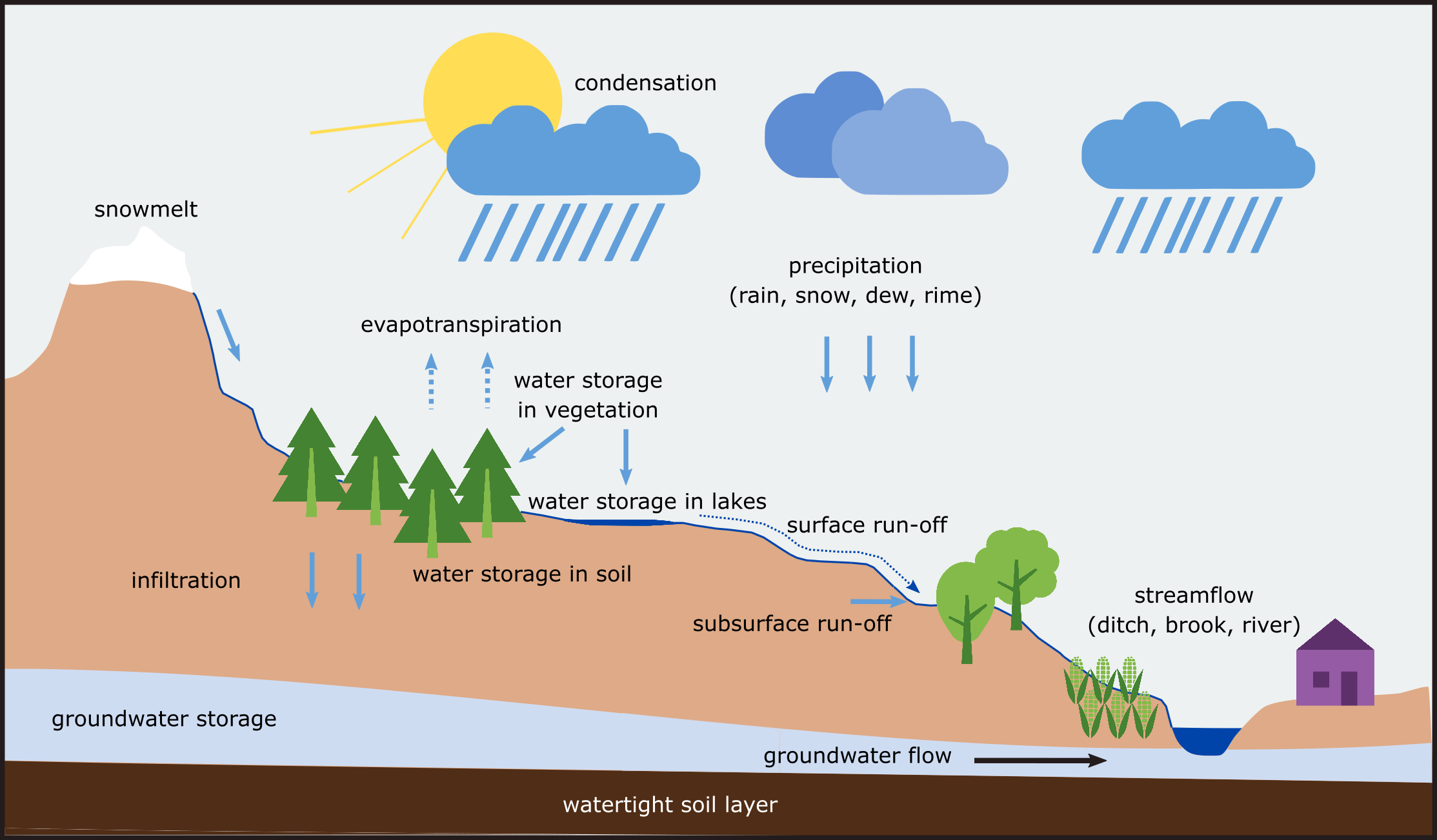
Floods form as a result of prolonged and widespread precipitation, sudden and localised heavy rainfall, or in winter and spring as a result of snowmelt. When rain hits the earth's surface, part of it seeps into the soil and contributes to groundwater recharge. Another part is temporarily stored in the soil or evaporates, and the rest flows over the soil surface as surface runoff into water bodies (Figure 1).
Figure 1: The emergence of surface runoff. Source: Matthias Rothe / UBA
How much precipitation percolates and how much runs off on the surface depends on the properties of the soil, the degree of sealing, and the topography of the landscape: If the soil is already saturated with water from previous precipitation events, or the ground is frozen, most of the precipitation will run off at the soil surface. Soil type, degree of soil compaction, and vegetation also determine how much water can percolate into the soil per unit of time. Steep valleys, channelised waterways, and a high degree of soil sealing, as found in many developed areas, favour rapid surface runoff.
Small streams subsequently contribute to a rising water level in larger streams during heavy precipitation events. The overflowing of riverbanks is determined by the rivers´ morphology and amount of water. Rivers have more or less developed floodplains. The amount of water retention volume in the floodplains determines how fast flood waves pile up. The more volume is available for the retention of water during a flood, the slower the water flows downstream – the flood wave is less steep.
Floods are amplified by humans
Although floods are natural events, humans influence the likelihood of floods, their progression, and the damage they cause.
Massive human intervention in the course of water bodies
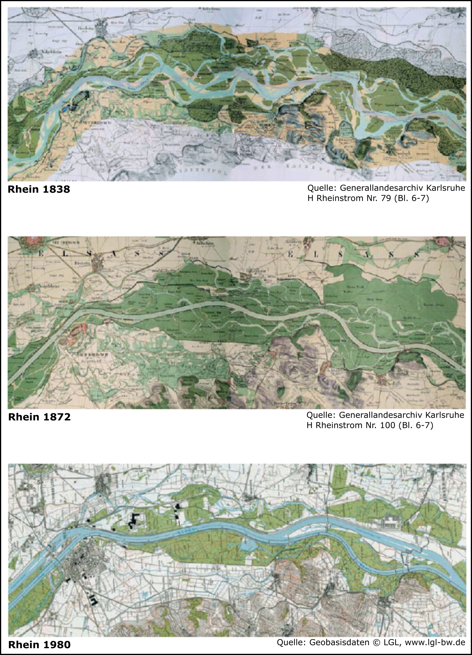
Massive human intervention in the course of streams and rivers and in the landscape has a direct impact on the course of a flood. Most flowing waters in Germany have been straightened, dyked and dammed in the past to gain settlement space or agricultural land or to use them for navigation or hydropower (example Rhine in Figure 2). As a result, fewer natural floodplains are available today. This hampers the retention of water. River courses have also been shortened. As a result, the flow velocity of rivers has increased. The runoff from many tributaries concentrates more quickly in a riverbed. Flood waves therefore run faster today: More water is transported in a shorter time, and the flood wave is steeper - water levels are higher.
Figure 2: Changes in the course of the Rhine River due to development measures. Source: Generallandesarchiv Karlsruhe; es gelten die Veröffentlichungs- und Vervielfältigungsrechte des Landesarchivs BW / Geobasisdaten LGL
Change in the landscape due to development and agriculture
The landscape in Germany is highly urbanised. In some cases, rainwater can only seep away locally to a small extent. Water retention in the landscape is limited. In order to make land usable for agriculture, wetlands have been drained and soils dewatered through the installation of drainage systems. Intensive farming and the use of heavy agricultural machinery lead to soil compaction and consequently to reduced water permeability. Vegetation is also important for water retention in the landscape: A continuous vegetation cover on agricultural land reduces the development of surface runoff; also, the density of forested areas is crucial for water retention.
Areas used for settlement and traffic have an effect on the development of floods, as they have a particularly high degree of sealing. Rainwater can only percolate through sealed surfaces to a limited extent and is discharged directly into water bodies via sewage systems. For Germany, the official land statistics quantify 51,315 square kilometres (km²) of settlement and transport areas at the end of 2018. 45.1% of this urbanised surface is sealed, according to the Federal Statistical Office. In terms of total surface area, the share of settlement and transport is 14.4% and the share of sealed land is 6.5% - every day 52 hectares of land are converted for settlement and transport purposes. This corresponds to the area of approximately 73 soccer fields (in German: (UBA 2021).
Man-made global warming
The natural water cycle is intensified by global warming. The atmosphere can absorb a lot of water vapor at high temperatures and less at low temperatures. For each degree of warming, the absorption capacity for water vapor increases by about seven percent. More water vapor in the atmosphere means more precipitation. In warmer climates, an increase in precipitation extremes can therefore be expected, especially during summer months. Analyses indicate an increase in the frequency and intensity of extreme precipitation events in recent decades. However, the results differ considerably depending on the region and season (IPCC 2014).
In addition, to the intensification of the hydrological cycle, the weakening of the temperature gradient between the subtropics and the Arctic - which has warmed three times as much as the rest of the world in recent decades - is leading to longer-lasting and -regenerating weather patterns (ESKP). This can lead to prolonged periods of heat and drought as well as prolonged periods of continuous rain. While weather extremes have always existed, climate change is increasing the frequency and intensity of such extreme rain events.
Climate-induced changes in runoff patterns
Scientific studies show that river floods in north-western Europe have increased in recent decades. At the same time, river floods in southern Europe decreased, due to lower precipitation and increased evaporation (Blöschl et al., 2019).
The range of changes in runoff expected due to global warming can be quantified based on different climate model projections (so-called ensembles) compared to a reference period. The calculations are performed using water balance models. Model implementation is continuously improved and is the subject of research. Calculations (in German: KWRA 2021) on the annual flood discharges (characteristic value: mean annual flood MHQ) of the major rivers in Germany show clear differences between the optimistic (15th percentile of RCP8.5) and the pessimistic (85th percentile of RCP8.5) case for the middle of the century (2031-2060) (Figure 2). If the optimistic case results in no or only moderate changes in flood discharges, the pessimistic case results in a significant increase. At the end of the century (2071-2100), isolated moderate increases in flood discharges are projected in the optimistic case and generally increased, sometimes significantly increased, annual flood discharges are projected in the pessimistic case (Figure 3).
Figure 3: Simulated mean changes in annual flood discharges (MHQ).
Shown are the simulated relative mean changes in annual flood discharges (MHQ) for various 30-year periods compared to the 1971-2000 reference period. In each case, an optimistic (15th percentile) and a pessimistic (85th percentile) scenario is given based on the representative concentration path 8.5 - "continue-as-is". Data source: German Federal Institute of Hydrology.
Source: Verändert nach Klimawirkungs- und Risikoanalyse 2021 für Deutschland Teilbericht 3: Risiken und Anpassung im Cluster Wasser. Datenquelle: Bundesanstalt für Gewässerkunde
Side note: Climate models, climate model projections and model ensembles
Climate model projections are used to estimate the response of the climate system to different greenhouse gas emissions. A range of assumptions about the amount and pace of future emissions helps scientists to develop different emission scenarios - so-called "relative concentration pathways," or "RCPs" - on which climate model projections are based. Climate models allow us to reproduce the most important processes in our climate system and to calculate possible climate changes for different plausible future scenarios. In recent decades, increasingly detailed models of the Earth's climate system have been developed. Each climate model represents the processes in the climate system differently. All climate models together are called a model ensemble. A model ensemble describes the range of possible climate changes and helps us to understand their uncertainties (IPCC 2014).
Climate projections are explicitly not true forecasts, because every model simulation of future developments is based on certain assumptions. These assumptions are hardly predictable because they are influenced by people and their behaviour (Deutsches Klimakonsortium).
Further information on climate model projections as well as facts on climate change can be found on the pages of the German Environment Agency (Climate models and ensembles and Climate change) and also under the following links (in German):
In addition to climate-induced changes in the water balance and human intervention in the course of water bodies, property values in former floodplains and inundation areas are increasing. This contributes to a further rise in potential damage. Residential buildings, industrial facilities as well as transport infrastructure have been built. Damage from floods occurs primarily where humans have settled in the original floodplains. If a flood hits a settlement or an industrial area, very high damage can occur.
To protect society from the negative consequences of floods, comprehensive risk management is needed, including preparedness, flood warning, acute hazard prevention, aftercare and evaluation. On the following pages you will find more information on the aspects mentioned:
Blöschl (2019): Blöschl, G., Hall, J., Viglione, A. et al. Changing climate both increases and decreases European river floods. Nature 573, 108–111 (2019). https://doi.org/10.1038/s41586-019-1495-6
IPCC 2014: Klimaänderung 2013: Naturwissenschaftliche Grundlagen. Häufig gestellte Fragen und Antworten – Teil des Beitrags der Arbeitsgruppe I zum Fünften Sachstandsbericht des Zwischenstaatlichen Ausschusses für Klimaänderungen (IPCC) [T.F. Stocker, D. Qin, G.-K. Plattner, M. Tignor, S.K. Allen, J. Boschung, A. Nauels, Y. Xia, V. Bex und P.M. Midgley (Hrsg.)]. Deutsche Übersetzung durch die deutsche IPCC-Koordinierungsstelle und Klimabüro für Polargebiete und Meeresspiegelanstieg, Bonn, 2017.
The UBA’s motto, For our environment (“Für Mensch und Umwelt”), sums up our mission pretty well, we feel. In this video we give an insight into our work.
The UBA
Contact
Wörlitzer Platz 1 06844 Dessau-Roßlau GermanyPlease contact us exclusively by e-mail: buergerservice [at] uba [dot] de. Unfortunately, we are currently not available by telephone. There may currently be delays in answering enquiries. We ask for your understanding.
 Click to enlarge